Show Navigation
Notices tagged with noaa, page 3
-
#NOAA / #NWS alerting for Winter storm, extreme cold in #NE and #IA. Up to 5 inches of snow could accumulate. Wind chills could be as low as -20F. Tomorrow evening through Saturday evening, with Eastern areas getting it later than Western areas.
I have not been to either place in Winter, so that may turn out to be picnic weather. But if the Weather Service sends alerts, it probably means what it says.
-
As #NOAA / #NWS continues to send alerts (probably approaching fifty now), the phone says "would you like to temporarily mute this conversation?"
-
#NOAA / #NWS is alerting for severe #t-storms in the Kansas City #KS and #MO area, with 80MPH straight line winds, hail. The storms are moving E and NE at 60-85 miles per hour, double the usual speed.
These storms are dangerous. If you're in the area, pay attention to weather alerts. If there is an alert for your area, seek shelter immediately.
-
#NOAA / #NWS alerting to a possible #tornado or two near Sedalia #MO. Affected areas include Boonville, Prairie Home, Sedalia, Syracuse, #I-70. Hazards: tornado, half dollar size hail, straight line winds.
Mid-Missouri take heed.
-
#NOAA / #NWS alerting for #tornadoes
* Watches -- conditions right for tornado formation -- across nearly all of #MO, plus neighboring areas in other states including #IL.
* Warning -- radar indicated rotation N of KC in Buchanan, Clinton, DeKalb counties in MO; affecting #I-35, Cameron, Plattsburg, Gower, Cosby and other nearby communities. Moving NE at 35MPH
If you are in the area, pay attention to weather alerts.
-
Category 4 #hurricane #Sam passing well to the East Northeast of the Northern Leeward Islands, so #PR, #USVI, #BVI and many other islands and nations are spared.
#NOAA / #NHC https://www.nhc.noaa.gov/
-
#NOAA / #NWS alerting about potential #tornado conditions in the Kansas City area of #KS and #MO. These are watches (conditions favorable for formation), not warnings (actual tornado detected). If you’re nearby, pay attention to your local news, your cellular phone’s alert, and your weather radio alarm.
-
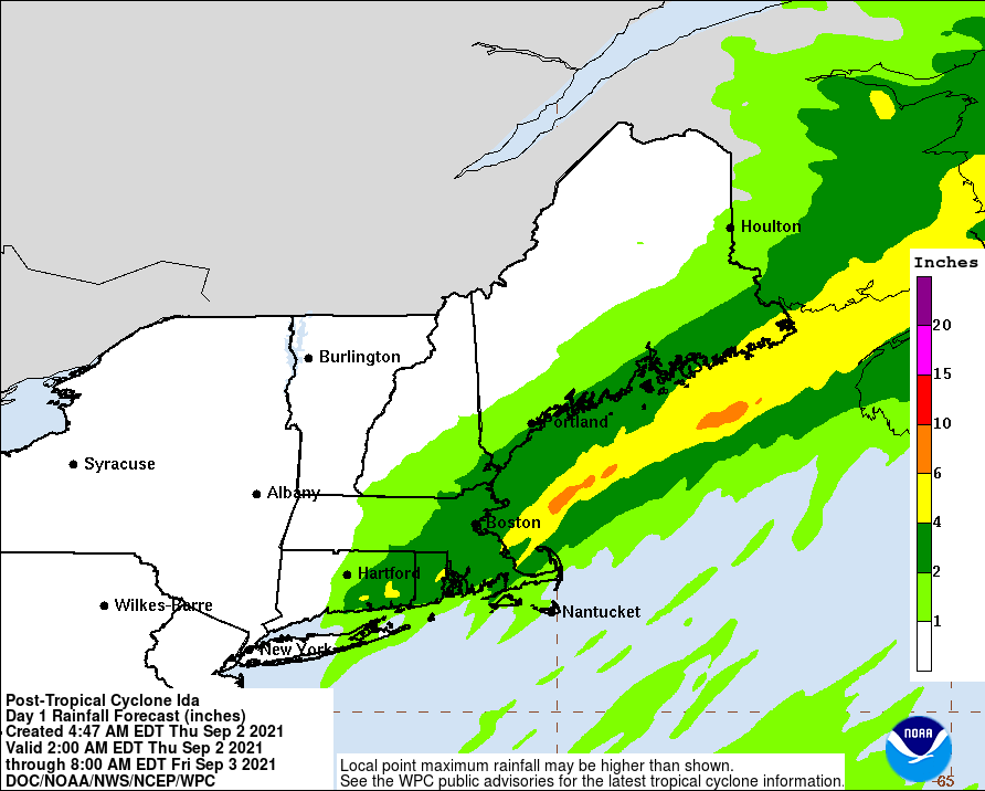
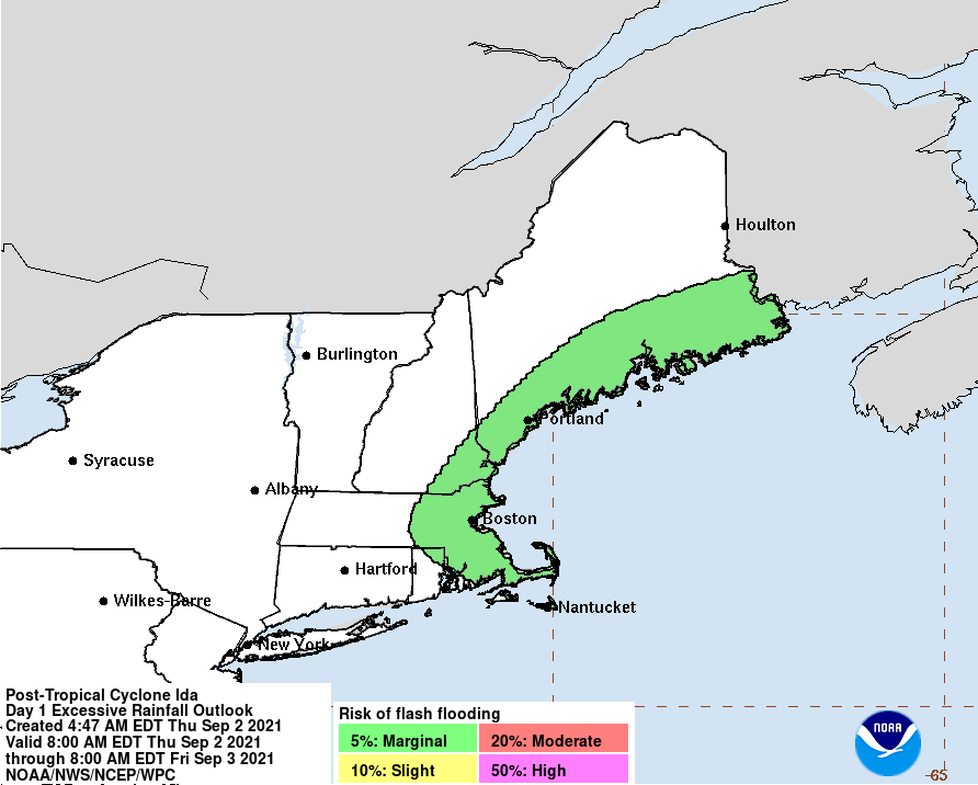
#NOAA / #WPC rainfall graphic for #Ida over the next few days: https://www.wpc.ncep.noaa.gov/tropical/qpf/Ida_rainfall.gif and areas where excessive rainfall may cause flash flooding https://www.wpc.ncep.noaa.gov/tropical/qpf/Ida_ero.gif
-
#TD #Ida now centered in North Central #Mississippi. As a weakening tropical depression, advisories about Ida will be issued by #NOAA / #WPC instead of NOAA / #NHC.
> ...HEAVY RAIN AND FLOOD THREAT WILL CONTINUE TO SPREAD ACROSS
> PARTS OF THE TENNESSEE AND OHIO VALLEY OVERNIGHT INTO
TUESDAY...
-
Source: #NOAA / #NHC https://www.nhc.noaa.gov/
-
In the eastern Pacific, there is now Tropical Depression Nine-E ( #TD-9E ), expected to be a tropical storm by Monday; and also #TropStorm #Hilda, which should be a hurricane soon. Both are headed West-Northwest, away from land.
The #NOAA / #NHC site does not imply that these storms could head for Hawaii, so maybe they can lift some oceanic heat high enough into the atmosphere to allow some of it to escape.
-
Looking at the #NOAA satellite view. There's a line of storms shooting from the SE corner of Nebraska, across the bottom of Iowa and top of Missouri, broadening out in Illinois, Indiana, Ohio, and starting to enter parts of Pennsylvania and New York. If you're in any of those areas, prepare for what looks like a pretty strong bunch of #t-storms.
#NE #IA #MO #IL #IN #OH #PA #NY
-
My area is covered by #NOAA weather radio, except my specific portion is in a dead spot.
#CA has some humongous counties, so county-level alerts can sometimes be too general.
-
#NOAA / #NWS alerting for #t-storms in #San_Bernardino County !SoCal. Big Bear City, Big Bear Lake, Lucerne Valley, Johnson Valley, Woodlands, Fawnskin, Baldwin Lake, Sugarloaf, portions of #SR-38 and #SR-18. Winds in excess of 40MPH, pea sized hail. More storms will form and dissipate this afternoon, so monitor local broadcast outlets for local warnings.
-
Now #t-storms spreading to mid-Missouri also.
#KS #MO #NOAA #NWS
-
#NOAA / #NWS alerting about severe #t-storms in the Kansas City area. 60MPH - 70MPH wind gusts and penny to quarter sized hail. Expect damage to trees, roofs, siding, vehicles, mobile homes, outbuildings.
https://www.weather.gov/
-
#NOAA / #NWS alerting for severe #T-storms across the Kansas City area and Southeast Nebraska. 60MPH to 75MPH wind gusts have been measured, so expect wind damage to roofs, windows, vehicles, trees.
#KS #MO #NE
-
Tornado watch ( = conditions are right for tornadoes to form ) for mid-Missouri, Northern, Northeastern, and Eastern Missouri, and for adjacent areas of Illinois. Probably more, but this is where I just got alerts for. Watches last until 02:00 Saturday morning.
If you're in any of those area, be ready to react to tornado sirens of #NOAA / #NWS alerts on weather radio ( you do have a weather radio, right? ) or your cellphone.
-
#NOAA / #NHC #TropStorm #Elsa briefly reached #hurricane status again off shore of Tampa Bay, but is now a tropical storm again. Storm surge, tornadoes, wind and rain all expected across the US Southeast over the next few days.
If you're in #FL, #GA, #SC, #NC, #AL it is probably too late to do any additional preparation. Just try to ride it out.
-
#NOAA / #NHC: #Hurricane #Elsa now a #TropStorm, currently affecting #Haiti and the #Dominican_Republic, expected to pass near #Jamaica before hitting #Cuba.
Still expected to affect #Florida between Monday night and Wednesday morning. If you're in the Caribbean or #FL, get ready now.
https://www.nhc.noaa.gov/

 LinuxWalt (@lnxw48a1) {3EB165E0-5BB1-45D2-9E7D-93B31821F864}